Difference between revisions of "UFOs and the Third Reich - The Road to Agartha"
(→Some keywords) |
(→Some keywords) |
||
| Ligne 44: | Ligne 44: | ||
Google: “antigravity germany”. | Google: “antigravity germany”. | ||
| − | On the first two results, interesting things emerged. A book entitled “The Secret of Anti-Gravity” | + | On the first two results, interesting things emerged. A book entitled “The Secret of Anti-Gravity” or “in the shadow of the Third Reich and NASA” is presented as a “realistic” survey: |
[[image:Verites_pour_l_histoire_secret_antigravite.jpg|thumb|The secret of anti-gravity: In the shadow of the Third Reich and NASA. By Louis Christian Gautier, 2008]] | [[image:Verites_pour_l_histoire_secret_antigravite.jpg|thumb|The secret of anti-gravity: In the shadow of the Third Reich and NASA. By Louis Christian Gautier, 2008]] | ||
Version du 10:25, 25 mai 2022
The following story may be worth telling. I am generally reluctant to report personal anecdotes, I always fear that it is a story of misplaced ego (!)... But... sometimes, the experience is so striking that it deserves to be told. It begins, as often enough finally, during a peaceful night during which I have an improbable dream, the space is vibrating with energy, luminous and colored:
Sommaire
- 1 Dream (mid-August 2014)
- 2 First Searches
- 2.1 Some keywords
- 2.2 A 2006 documentary on TV Channel Russia
- 2.3 Nazis flee to Latin America
- 2.4 The 1938-1939 expedition: the foundation of the myth of Agartha
- 2.5 The Russian army would have got their hands on secret documents indicating the route to Agartha
- 2.6 The doctrine of the Ahnenerbe?
- 2.7 Analysis of the cards presented
- 2.8 A passage using the moraine of the Jutulstraumen glacier?
- 3 Conclusion
- 4 Appendices
Dream (mid-August 2014)
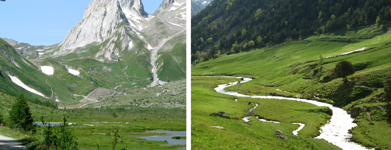
I do not have a physical body. I am floating in the air and observing, about 3 kilometers above sea level, a green valley at the bottom of which a stream unfolds its arms. The valley is surrounded by high mountains. It is a wild valley. I don't remember seeing any dwellings, this place might looked like Switzerland.
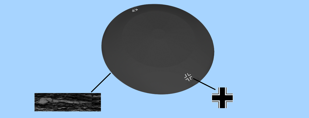
I observe from afar evolution of a metallic disc, in the shape of a frisbee. What is strange is that it deforms while moving, depending on its direction of movement, it becomes concave or convex. It appears to be floating in the air, swaying from side to side in slow, sweeping motions.
It has like "scales" on its surface, as if large plates of metal overlapped and under the stress caused by the twists of the surface. Although the following image is a cutaway view, his scales looked a bit like this:
The color was dark-grey, anthracite. Then, “I understand” that I am watching a film. I therefore "think" that I must be able to stabilize the image and get closer to the phenomenon by modifying the image parameters. And indeed, I can then get closer "virtually" and, I observe strange things:
There are crosses on the sides of the device. These are clearly "Nazi crosses". But not "swastikas", they are straight, exactly like this:
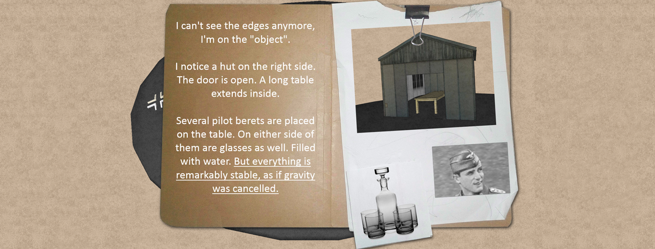
At this time the craft lost its initial shape, it now really has a "classic" flying saucer shape. Its surface is smooth. And above all I observe at this stage a "hut" (house made of boards) placed on the top of the aircraft instead of the cockpit (!).
Let's not be afraid: I "zoom" on the cabin to the front door. And there what I see intrigues me: there is no one, but a large table on which are placed 5 or 6 berets. They have an elongated shape, (I do research and it could coincide with the berets of Lutwaffe officers). But, what what fascinated me was that there were glasses and a carafe of water, and they were all perfectly still and stable on the table. Even as the phenomenon swayed significantly, nothing moved inside. I then thought in the dream that there must be something overriding gravity.
And... right after that, I woke up!
First Searches
Some keywords
I had heard about the myth of Haunebu, these famous saucers which would have been manufactured by the Nazis. I think that everyone who is interested in the subject ends up, one day or another, seeing these drawings on the Internet. However, I had never taken an interest in it: it is a subject that I have always found "too offbeat" to coincide with the slightest reality, even today, then during the Second World War!
Despite this, challenged by the ideas, and because the subject of the dream seemed rather to deal with anti-gravity, I started looking for information on anti-gravity and the Nazis:
   Google: “World War II antigravity”
   Google: “antigravity germany”.
On the first two results, interesting things emerged. A book entitled “The Secret of Anti-Gravity” or “in the shadow of the Third Reich and NASA” is presented as a “realistic” survey:
“Gravity is the most important source of potential energy. A craft using it could reach the speed of light. At the end of the Second World War, Americans and Soviets seized the scientists of the Third Reich and thus appropriated all their work, research... and discoveries
Among these war prizes was the research on gravity, carried out by SS Colonel Hans Kammler who reported directly and only to the Black Order Reichführer Heinrich Himmler. Americans soon found that their own researchers would refuse to recognize this revolutionary science. Indeed, the National Socialists had a totally different approach to science and engineering than others, as their ideology was also based on a different worldview. Have the Americans mastered all the technologies that have fallen into their hands? This is what the British Nick Cook, a renowned aeronautical journalist, sought to find out. His investigation quickly became a fantastical quest in space and time…”
I bought this book and read it diagonally: if it is very interesting and sourced (the elements indicated are generally found in wikipedia or on the net), it is mainly interested in "the post-war period", that is to say what has become of the research on antigravity on the English and American side and on the basis of the elements developed by the Germans. However, I was looking more specifically for information on the source.
A 2006 documentary on TV Channel Russia
A forum of of questionable reputation now closed presents an amazing video, in Russian, titled “3rd Reich: Operation UFO, Antigravity and Galactic Portals”. Its first broadcast was reportedly in 2006 on TV Channel Russia.
This documentary was punctuated with archive images of which I do not know the source: in summary, the Germans would have developed prototypes (Haunebu saucers) without having the time to industrialize them and make them operational for the war. In connection with this subject, the company "VRIL" (mystical-esotherical society) would have been the sponsor of these devices. Here is, I think, another good page on the subject: http://soldatsminiaturesdusergentgarcia.over-blog.com/pages/ovnis-et-armes-secretes-nazies-6299827.html
Nazis flee to Latin America
Either way, the story turns romantic when, in the closing months of World War II, many Nazi criminals feel it is time to flee to escape prosecution.
If some try to organize their escape on their own, a good number of them will benefit from real channels which will allow them to hide for decades in the shadow of the South American dictatorships: Brazil, Argentina, Chile and some also claim to Antarctica!
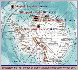
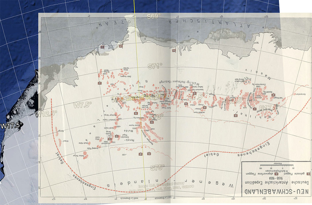
In particular, they would have taken advantage of an exploration campaign previously carried out in Antarctica between 1938 and 1939, in an area they called "Neu-Schwabenland" (New Swabia):
And the myth takes shape here: during this campaign, thanks to submarines, the Germans could have found a passage under the ice leading to vast hidden areas which they call the "Agartha": the myth of the hollow earth ... A place described according to some sources as a small paradise under Earth... In this place, they would have established bases there.
It is these same bases which would have, at the end of the war, served as a refuge for many German scientists, including those who would have worked on the “UFO” prototypes, but also for many German submarines never found! On this subject, submariners did not hesitate to go to incongruous places: in 2012 U-boat was found 100 km off the coast, at the bottom of a river, in the middle of Canada!
Of course, for UFOs and Antarctica, this is most certainly more myth than reality. But often the myth is built on a part of truth and that's where it's interesting :-)
And, it is true that during my readings on the subject there are at least two things that surprised me.
The 1938-1939 expedition: the foundation of the myth of Agartha
Pursuing some research on the expedition to Antarctica, I watched this rather surprising report, because it was full of maps: http://www.youtube.com/watch?v=DB9f30cNYDA#t=218
In particular, it is possible to see a leaflet that contains instructions for a submarine to reach the caches under Antarctica. Entitled "Map for the passage of the depths of the ocean". Intriguing, because it is a photo of the flyer held at arm's length. If someone had fun making a fake, they went to great lengths: in general, you might as well scan a flat document and present an A4, it's easier.
It intrigued me. At first, starting from the video report, I tried to zoom in on the images and reconstruct the map part by part. In particular the details located at the bottom, providing indications of direction and distance.
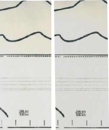
You will find this reconstructed map in high resolution in PJ (Neu Schwabenland _ instructions.jpg). Then finally, using Google Image, I found sources closer to the origin. At first, they made me doubt: in fact, I realized that the image elements found, although representing the same part of the leaflet, were not quite identical. How could this be possible?
Of course it's not obvious and you have to be quite careful, but as I had "the nose on the photoshop layers", to the pixel, I quickly realized it: above, you have two sources different: the pencil lines are not the same, as well as the size of the font chosen for the characters printed at the bottom.
Below is another example: two photos of another part of the leaflet, but with different folds and additional indications in red on one and not on the other (if you guess what these indications say , I'm a taker. These are astrological signs with certainly hourly positions, but why?):
So I wondered if there were several cards and why a counterfeiter would have "amused" making several copies to make a "hoax". This intrigued me more and more.
Finally, I ended up finding a site in Russian, quite well documented and thanks to which I was able to find an explanation: http://tayni.info/44161/
Here is the link with the translation:
The Russian army would have got their hands on secret documents indicating the route to Agartha
On this web page, you will find elements extracted from a report which evokes the seizures of documents carried out by the Red Army, at the end of the Second World War.
This report consists of an investigation carried out by the Russians on the Ahnenerbe. The Ahnenerbe was an archaeological research institute, seeking to prove the Nazi theses on the Arian race, would be connected to the Vril secret society and to the saucers.
But here too, be careful! As much as the existence of the Ahenerbe is recognized and has a historical character, the existence of the Vril society (and its supposed link with the Ahenerbe) falls within the domain of sulphurous hypotheses, built from elements of pure fiction.
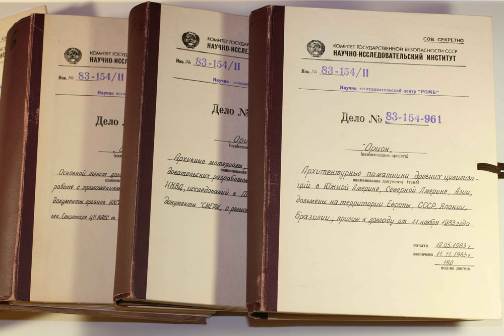
The books below, dated May 1983, present the results of this investigation, in particular the part concerning the "Orion" project (this is their title):
I don't know exactly what the Orion project covers, except that the Russians were compiling Nazis research and documentation about their obscure project to identify and locate ancient forgotten knowledge.
Still on this site, some of the documents that would have been seized by the Russians are shown, in particular these leaflets/cards, presented here in the form of “bundles”: seeing this photo, I then understood why I had several images:
And here is the explanation: during the Second World War, the best way to keep a secret was to make the prisoners of the camps work, who were going to be… exterminated. In particular, the Jewish prisoners of the camps worked on the transcription of ultra-secret documents and projects. These cards would have been reproduced (by hand) in a little less than two thousand copies.
The doctrine of the Ahnenerbe?
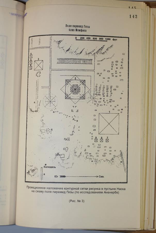
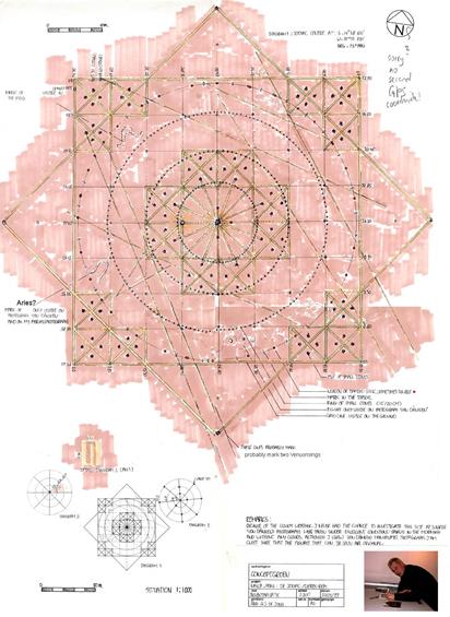
The translation of the site made by google refers to the idea of a very old civilization (extra-terrestrial) which would be at the origin of the great constructions on earth and in particular the pyramids. And, I was really flabbergasted by this map, supposedly from one of the books in the report:
There you go again, the pyramids, but not only!
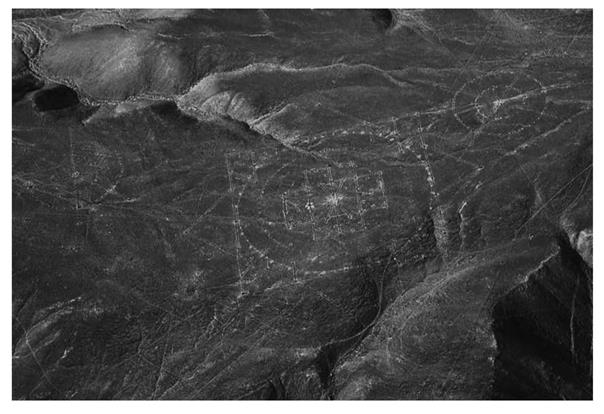
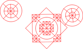
It may not strike you, but superimposed on the Kephren pyramid, on the page presented here, there is a strange symbol - rare - and correctly represented: it is a Nazca geoglyph, little known to the public . Personally, I had noticed it in 2005, when I was interested in the geoglyphs of Nazca: at the time I wrote an article entitled “Nazca: a network listening to the anger of the mountain? ”.
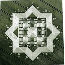
In 2007, when I discovered that the crop-circle makers had represented him in the fields in 2000, I fell head over heels! On July 30, 2000, in Morgan's Hill Wiltshire, a crop-circle took up the symbolism of it, very explicitly:
Why so much interest in an "obscure" petroglyph? This demonstrated a good culture on the part of the crop-circle makers. I then carried out additional research: there must not have been more than 4 or 5 websites which referred to it and still under quite different names. Since then we find this symbol in bulk under different names: "Nazca star", "Gigantic Geometrical Formation - GGF" (Erich von Daniken), "Zodiac", "Geometry Glyph", "Nazca Mandala", "Sun and Star", " Palpa Estrella”, “Nazca Matrix”, etc. http://wikimapia.org/#lang=en&lat=-14.644208&lon=-75.171297&z=19&m=b&v=8&tag=46520&show=/19628431/Palpa-Estrella-Sun-Star
On one site, the discovery is attributed to June Choate who noticed this particular geometric formation in 1983 in Pampa. A reference would be given in "Ancient Skies Volume 15, Number 1, March–April 1988, p4".
This formation seems to predate the Nazca culture, it would be Paracas. From the ground, we don't see much (on this video presented “as unique in the world with 734 visits (!) http://www.youtube.com/watch?v=PoD9BrY6_64): It is made from or before the Paracas culture (laying stones for drawing; against the Nazca culture cleaning the floor and watch it blank)”. It is quite different from the other Nazca glyphs and it is not located next to the other lines, but higher up. It is more subdued, and its symbolism clearly geometric.
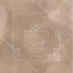
However, if the crop-circle makers “arrange” reality by caricaturing it (often it is made more “geometric and smooth”), the symbol remains very recognizable. Here is its original layout:
However, when the crop circle appeared, I don't think anyone had made the connection. (see http://www.crop-circles.info/index.php?v=s&y=2000). This formation was very little known. Idem, on July 3, 2005 a second crop-circle represents its central part, and here too I think that nobody made the connection:
Personally, I was very surprised that the crop-circle makers (admittedly sharp in symbolism) knew about this formation.
But why, and what does this symbol represent? There are various assumptions.
Gilbert de Jong, a German made a precise survey of it, he compared it to a zodiac, with cardinal directions:
Hermann Bossi discusses coded information about the star HD 42807 and its planetary system.
In another book in Russian on Google, a hypothesis is that: "А Дмитрий нечай увидел в ней связь непосредственно с Великой пирамидой в Комплексе гизы. Translation-Google: “Flashed (?) a version that "Estrella" is a diagram of the Giza plateau, located in distant Egypt. And Dmitry Nechay saw it communicates directly with Great Pyramid of Giza in the complex.” Here we are again. In any case, I was very surprised to find this geoglyph, fully and correctly represented, in a book in Russian supposedly published in 1983. Which means that if this book is correct, the Germans had already spotted this geoglyph in the years 1940/1945...
The report explains that the Germans would have succeeded in crossing the geometric properties of ancient sites (the pyramids and the site of Nazca) and that this would have enabled them to find the remains of an ancient civilization that had disappeared.
So, of course, it's more speculative, but it puts quite a few "coincidence" researchers on the trail. You will recall that in another report on the pyramids, a number of ancient sites on Earth are lined up which caused a stir a year ago: "The Pyramids Revelation". This may explain why some seek relationships between these sites:
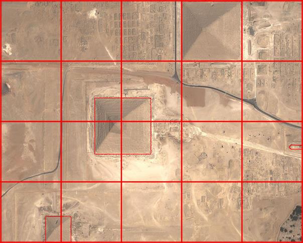
Without looking too far either, a certain number of "researchers" have presented the site of the pyramids superimposed on a grid system whose "step" is that of the great pyramid.
System on which it is possible to have fun superimposing the Nazca geoglyph and looking for correlations, in particular with the directions of the stars...
Anyway, not having access to the other pages of the book, perhaps containing explanations, there is reason to ask questions and spend a lot of time... To study, with other sources on hand, if applicable.
Analysis of the cards presented
To return to the maps seen above, I wondered: if there was a passage under the ice, in Antarctica, thanks to the very recently published maps, would it not be possible to verify it? Indeed, recently, maps of the subglacial topology exist. Are the maps consistent with the reality known today?
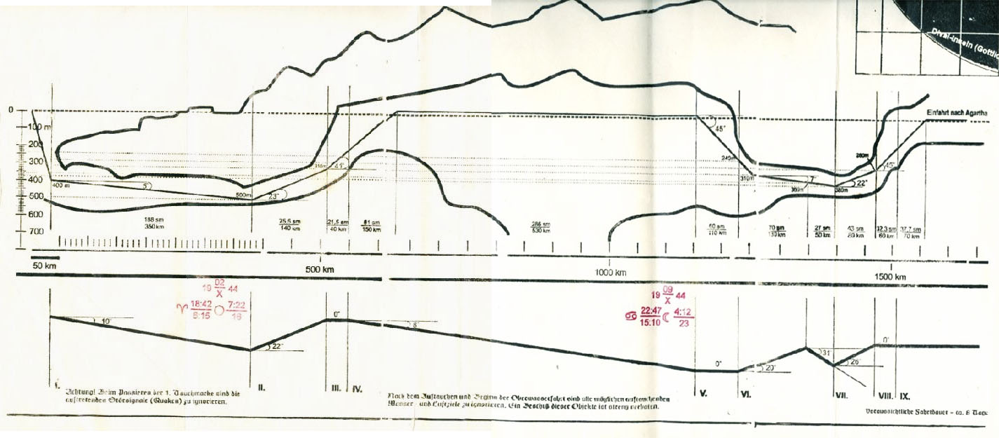
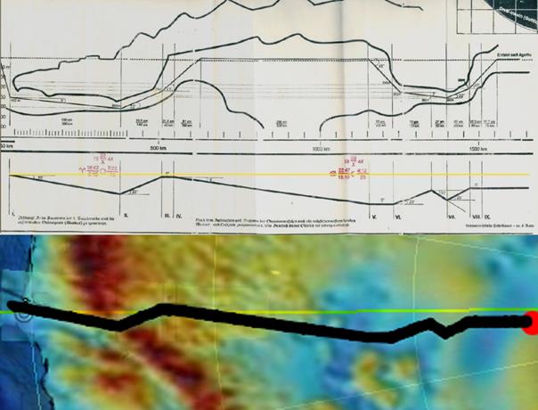
Here are the two plots, supposedly intended for submariners:
The first, the top one, presents a profile with the progress instructions in terms of depth/altitude. The dotted line representing sea level 0, you have to dive down to -500m at the lowest point. Starting from the ocean, we observe that the pack ice sinks and progresses below sea level.
The second profile, the lower one, corresponds to the azimuthal directions to be considered, seen from above.
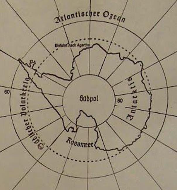
So with that can we reconstruct the journey on a globe? The subsidiary question is: if there is an entrance, where would it be? We can assume that this would correspond to the area explored in 1938-1939, somewhere in the “Neu Schwabenland”.
Precisely, on the map at the top right of the leaflet, we can read “Einfahrt nach Agartha”: Entrance to Agartha. Listed next to longitude 0:
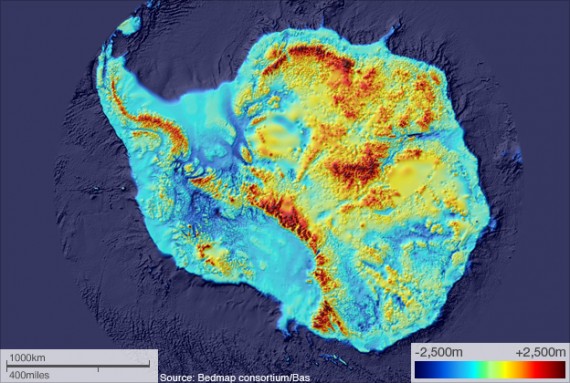
So I downloaded and searched for detailed subglacial maps in Antarctica. It is quite particular, there are places that go deep below sea level. Here is a general view:
The sea under the Antarctic continent can reach a depth of 2500m: there is enough for a submarine!
Where it becomes interesting is that at the level of the region explored by the Germans, there would really be only one possible passage: the region of Neu Schwabenland being made up of mountain ranges.
I decided to consider that if there was only one "acceptable" passage, it had to be this one. It starts precisely at longitude 0°.
A passage using the moraine of the Jutulstraumen glacier?
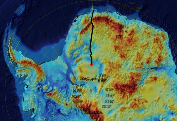
I made the assumption that this would be the injection point (the moraine of the Jutulstraumen glacier) and I superimposed the path presented on the map, in top view, and respecting the distances approximately:
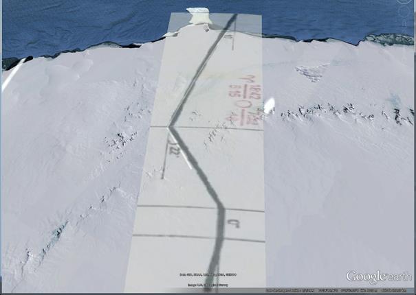
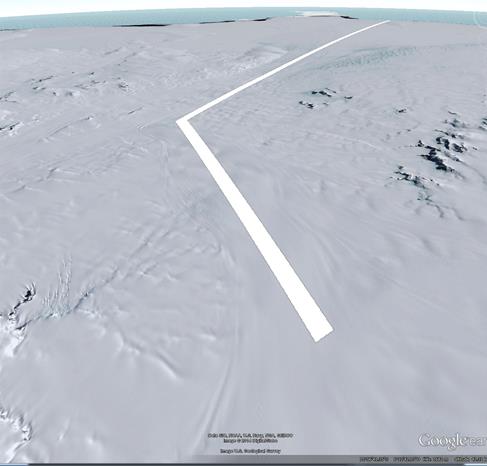
What is interesting is that this route precisely follows the route of the underwater gorge, it does make a bend at its beginning. On Google Earth, here are the first 500 kilometers plotted:
Make no mistake about it, distances are important! The width of the channel that sinks into the mountain range (where I stopped the white line) is about 15 kilometers. A submarine would have enough to pass! If we zoom in on the area, we realize that it corresponds to a frozen river "bed": a glacier that flows into the Antarctic Ocean and creates a tongue of pack ice that forms a point on the sea. .
The indications of angles given on the map are correct with respect to the meridians. 10° is indeed the entry angle, of the first section, then 22° the correction to be made. Further on, the route joins an area where the depth is at least 1000 meters below sea level, which may explain the "hole" presented by the profile. The entrance to "Agartha" is only made after 1650 km of travel, in an area located approximately at sea level, again compatible with the map provided.
There are still a few anomalies to deal with, so I think my path is too short (it would be worth spending some time on the overlays).
Anyway, the story so far is quite interesting. The subglacial maps are very recent. So was it just coincidence? Note that there are also maps of Antarctica that show sea ice/ice cap levels and free sea levels under the ice.
Conclusion
Knowing the war was lost, the Nazi regime would have sought to ensure that the enemy would never lay hands on its knowledge. Matters of honor and/or ideology, he would have liked to take it all with him in death, voluntarily or not (http://en.wikipedia.org/wiki/Mass_suicides_in_1945_Nazi_Germany). Thus, the elements we observe today could have been part of a plan to eliminate a large number of German scientists, especially those who worked on sensitive military programs, as well as advanced equipment.
In this case, it was obviously not necessary to explain to the people concerned that they were going to be killed: they were intelligent and "reasonable" people. It was necessary to offer them a tailor-made story, which held up, and implemented tangible elements so that they "committed suicide" voluntarily: the idea of Agartha, this hidden paradise rediscovered on Earth, would be made credible to the support of maps and precise indications. It was also a way to come out with your head held high. It reminds me of those cults that commit suicide.
The imagery at work made me think of Jihad and the motivations justifying the sacrifice (the non-return): "You will go to paradise!" A missive sent by one of the Germans taking part in the trip also mentions that he will not be able to return, that this will be his last shipment.
It wouldn't be the first time the Nazi regime used a lie to eliminate individuals. For the gas chambers, the victims were asked to undress under the pretext of taking a shower and brought to airtight rooms camouflaged as shower rooms, where they were locked up and gassed from the outside. All this seems all the more realistic, as this operation would have been carried out during the last days of the war.
Appendices
1. Is the autonomy of U-boats compatible with such a journey?
For most of them, underwater is not terrible, the outward journey could not even be offered to them: for the first generations, the underwater autonomy of u-boats is between 70 nautical miles (class IA), 80 nm (class VIIC) and 127 nm (class XVIIA). However, the underwater distance to be covered, on the first part of the journey, should be around 530 km: far too great.
The document begins with this indication "Nur fur kapitane von U-Booten der A-Klasse des Sonderkonvois des Führers" (Only for captains of class A submarines, special convoys of the Führer). What are these class A submarines and their characteristics? I couldn't find any specific instructions on this.
However, if we consider the most successful of the German submarines, the type XXI, the first copies of which were released in May 1944, it becomes possible. This submarine presented a real technological breakthrough: "Entering service in 1945, the fabulous U-Boot XXI was a technological marvel and a real concentrate of high-tech German innovations. Specialists consider it the first real submarine history and believe it represented a technological leap in the 1960s, about 20 years ahead of its time." (http://www.fortlitroz.ch/?page=v66) http://uboat.net/types/xxi.htm http://theudericus.free.fr/Mer_Ocean/UBXXI/UBXXI.htm Other sources claim that entered into service earlier it could have enabled the Germans to win the war in the Pacific.
He could also have achieved the feat of holding 530/540 kilometers under water (a distance that seems cut out for him). The difficulty: it would have to move at full speed underwater, that is to say before its batteries run out.
In view of the known technical information on the u-boat XXI, this route could seem possible for their captains. In addition, in the proposed scenario, the underground part carried out in the open air, over nearly 500 kilometers, allows the batteries to recharge before diving again. This helps to make the scenario "acceptable". They knew, of course, that they would run great risks beyond 280 meters depth (many sites indicate that the u-boats could dive deeper).
Be that as it may, in the event of sending personnel to their death, it was necessary to make them cross a point of no return, beyond which their submarine would no longer have the autonomy to return. 350/400 kilometers of diving being a minimum. Let's imagine that there is then no passage but a wall: then the whole crew would be irremediably and inevitably led to death (which the real cartography of the basement suggests).
2. Are these maps reliable due to ice variability ?
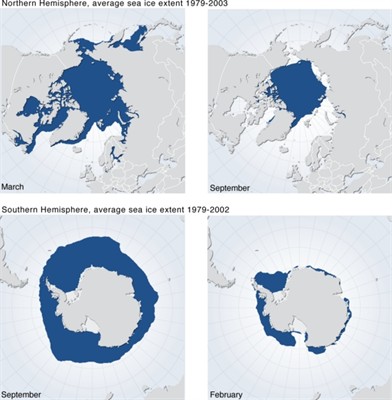
On the question of Antarctica, and the extension of the sea ice, I think it should be related to the summer, the temperatures vary enormously, in winter it is unaffordable.
On this part of the Antarctic coast, apart from the glacier flowing into the ocean, there are hardly any sources of ice formation. The place is very mountainous and the shore rocky. It is one of the closest places in Antarctica to the seashore.
It should also be noted that when I superimposed the maps of Neu-Schwabenland on the satellite views of Google Earth (based on the latitude/longitude plots presented on the maps), on the old map, I noticed edges of ribs slightly set back from what we see today. Contrary to what one might imagine. This being so, it is possible that it is an inaccuracy of time. In addition, Antarctica has been much less affected by global warming than the North Pole.
By means of both maps, it is possible to observe the same glacier flowing into the sea at longitude 0:
Finally, what the maps do not show is the submarine extension of the said ice. Then, it is indeed a rocky sub-glacial corridor that you have to follow.
Translation of instructions
Following this article, I had the opportunity to resume the translation of the instructions provided in German on the leaflet. The document appears very worked and certainly of time insofar as the fonts are not homogeneous. At one point in the instruction list, the starting point is clearly specified: I had not seen it, and it is all the better that I carried out this work independently. It corresponds fairly well to the position I had taken to make the path coincide with the corridor, i.e. 68°S, 1°E:
Only for the captains of submarines A-class special convoy Führer Submarine Fleet Navy German Reich.
Map of the passage of the deep sea.
Use only during maneuvers!
Instruction about the passage of spaces and corridors to the entrance to the Agharti.
IMMERSION AT COORDINATES: STRICT INTERSECTION: 68° DEGREES SOUTH AND 1 DEGREE EAST LONGITUDE AT THE DEPTH OF 400 METERS*
STRICTLY FOLLOW THESE INSTRUCTIONS!
1. Immersion. From the point of dipping low speed, roll to the right vby 10°, by the head, the angle of 5°. Distance of 188 nautical miles. Given the depth of 500 meters. (Because of the location in the corridor the pressure on the hull of the boat is no significant)
2. Ascent. Ballast down by the stern - the angle of lift of 23 degrees, roll in right at 22 degrees. 190 meters up. Distance 75.5 nautical miles.
3. A difficult maneuver. Ascent. Ballast down by the stern, lifting angle 41 degrees, straight ahead, 110 feet up, distance of 21.5 nautical miles. Next, roll in right at 8° before surfacing inside the grotto, distance 81 miles.
4. Movement on the surface inside the cave, with a roll in right at 8°. Distance of 286 miles.
5.6. Complicated maneuver! Immersion. The trim on the nose, angle of 45 degrees, to a depth of 240 meters, a distance of 60 nautical miles, continue to roll to the left by 20°, continue to dive until depth 310 meters to the entrance to the corridor. After 310 meters continue to dive down by the head, the angle of dip of 7°, up to 360 meters at a distance of 70 nautical miles. Next, roll in entitled to 31°, to a depth of 380 meters.
7. Surfacing, trim to the stern, lifting angle 22°, 100 meters up to the roll to the left by 26 degrees. Distance of 43 sea miles.
8. Ascent. Trimmed by the stern, lifting a 45-degree angle, always straight to the surfacing Agharti. Distance of 70 nautical miles.
9. Stir in Agharti full speed. Movement directly to the visibility of a new dawn. Changing the magnetic poles. On emotion compass arrows and arrow devices do not pay attention!
(The following instructions in the package number 3. Discover only at the entrance to Agharti!)
3. Agartha
In mythology, it would be an underground kingdom connected to all the continents of the Earth through a vast network of galleries and tunnels. This belief is found in antiquity. According to legend, large portions of these galleries still exist today, the rest having been destroyed by geological landslides. The mystery remains as to where the various entrances to these galleries are; entrances which may only remain open for a short time…
The capital of this Kingdom is Shambhala. This belief is closely linked to the world of Buddhism, but it is also found in the folklore of Tibet, Mongolia, China, Turkestan, Kashmir, Persia, Russia, France, Germany, etc
It would keep within it libraries of archives of the Lost Knowledge of the legendary submerged continents of Atlantis and Lemuria, would be the refuge of the "lightning men" mentioned in the Tjukurpa of the Australian aborigines and the Mohawk cosmology, but also of lost civilizations of the Mayas and Aztecs, as well as their hidden treasures before the arrival of the Conquistadors.
The Kingdom of Agartha is also the basis of the Hollow Earth proponents' theory, claiming that the interior of the Earth is not only composed of solid matter, but also of oceans, masses of land to which one can access through entrances present at the North Pole as well as at the South Pole, or through deep faults in the surface of the planet.
It has something to do with alchemy, in particular because of a form of energy called VRIL (it is the people of this underground Kingdom who would know how to use this "energy").
4. And anti-gravity in all this?
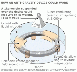
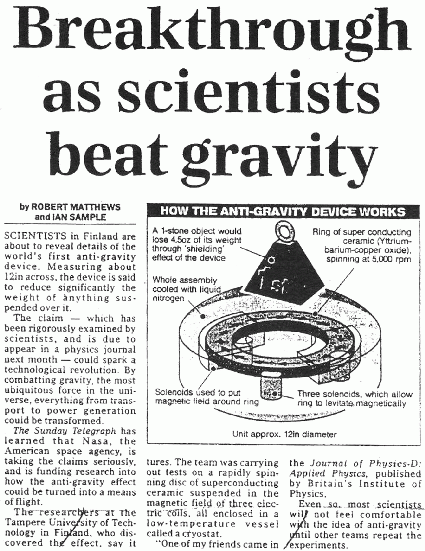
On the principle of electrogravity, many hypotheses are mentioned not not yet recognized and officially proven: strong magnetic fields, made from rotating superconductors in opposite directions. Dr. Podkletnov is cited as a major contributor: a materials scientist who made headlines in 1992, before being "ostracized" in his milieu, rightly or wrongly, I don't know. And though, his experiment has been replicated by other scientists, it still hasn't led to any real applications (sounds like the scenario happening right now with fuelless space engines, see the thread on EM-power on futura sciences: it's pretty crazy how "the old guard" defends the existing principles, denying the validity of ongoing successful experiments, including by NASA) For Podkletnov there is a video with the explanation of the principles: https://www.youtube.com/watch?v=JHN-yuRGGQM Google images is also full of illustrations with the name of this physicist and "anti-gravity":
Article in Sunday Telegraph (UK), September 1, 1996, page 3:
As the assembly seems surprisingly simple, it would almost make you want to buy superconductors to try! :-) (for superconductors YCBO would do the trick and not be too expensive).
It would be interesting to make a diagram of it, in the form of a historical frieze, with the list of actors (people/companies/organizations) and hypotheses about antigravity and even how they are related. There is also JL Naudin (Quantum site) who was quite interested in the subject and notably set up experiments (http://quanthomme.free.fr/energielibre/gravitation/GR_PageMenu.htm)
4. A video of this dream
